One morning in early April, Otis Kessler stepped onto the porch of his Kansas farmhouse and stopped before the screen door had finished swinging behind him. Nearly seventy acres of winter wheat lay beneath brown water, the green rows visible only in patches where the field rose by a few inches, even though no heavy rain had fallen during the night. He followed the flooded low ground with his eyes until it reached the northern property line, where Frontier Plains Financial had recently completed an earthen levee around its new logistics-development site. The structure had forced water away from an old natural route and toward fields the Kessler family had farmed for more than forty years.
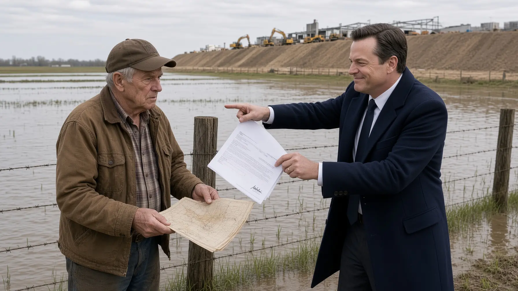
Otis stood there wearing an old canvas jacket over his pajamas, listening to meadowlarks call from fence posts above a landscape that suddenly looked unfamiliar. Water covered the lower wheat, pushed against two cattle fences, and filled a drainage swale that normally carried only spring runoff after a hard storm. He had watched that swale flood hundreds of times, but he had never seen water rise from the north on a dry night. Something about the direction bothered him before the amount of water did.
His twenty-two-year-old granddaughter, Mara, came outside carrying two mugs of coffee and asked what had happened. She had returned to the farm the previous summer after finishing a two-year agricultural business program, telling friends she would stay with her grandfather “until she figured out what came next,” though Otis suspected the farm was already becoming that answer. He pointed toward the northern boundary and said, “Water’s going the wrong way.” Mara stared at the flooded wheat and replied, “Water doesn’t usually get lost.”
Otis almost smiled. “Exactly.” He took the coffee, walked down the porch steps, and headed toward the machine shed without changing clothes. Mara followed because experience had taught her that whenever her grandfather said exactly in that particular tone, breakfast could wait.
The Kessler farm covered three hundred and twelve acres in Prairie Bend County, Kansas, with two hundred and sixty acres normally planted in winter wheat, milo, and soybeans while the remaining ground supported pasture, buildings, shelter belts, and low areas too wet to trust every season. Otis’s father had bought the first one hundred and sixty acres after returning from Korea, then added neighboring parcels whenever crop prices, bank terms, and family luck aligned well enough. By the time Otis took over in his thirties, the farm had become a modest but dependable operation rather than the kind of property agricultural magazines photographed from airplanes. Otis preferred dependable.
He had lived there almost his entire life. At seventy-two, he moved more slowly than he once had, wore hearing aids only when Mara reminded him, and still used a 1966 International Harvester 656 because replacing something merely for being old offended him economically. The tractor had belonged to his father, though enough hoses, bearings, seals, tires, electrical pieces, and one rebuilt engine had been replaced that Otis admitted only the serial plate possessed an unquestioned claim to 1966. It remained useful, and usefulness was the standard he trusted.
The farm also carried a forty-two-thousand-dollar real-estate note with Frontier Plains Bank, the lending subsidiary of the same financial holding company developing the property next door. Otis had refinanced five years earlier after replacing a well, repairing storm damage to the machine shed, and covering medical bills from the final year of his wife Ruth’s illness. The original amount had been larger, and Otis had reduced it aggressively whenever crops allowed. Forty-two thousand dollars was not enough to frighten him on a normal year, but flooded wheat had a way of turning ordinary debt into leverage.
Frontier Plains Financial had entered the county eighteen months earlier after acquiring more than six hundred acres beside a highway interchange two miles north of Otis’s farm. Its development subsidiary announced a sixty-eight-million-dollar logistics center containing warehouses, refrigerated storage, truck staging, and a distribution hub expected to create hundreds of jobs. County commissioners praised the project because property-tax revenue could stabilize local budgets and because young people had been leaving Prairie Bend County for decades. Otis did not oppose jobs, warehouses, or people making money.
What he opposed was selling land merely because someone else had already drawn a building where his field happened to be. Frontier Plains made three offers for part of the Kessler property during planning, then increased the proposal until it covered nearly the whole farm. Otis refused every time. He had no moral objection to selling land, but he disliked being told another person’s project automatically created an obligation for him to leave.
The bank’s development team wanted his property for several reasons. Part of the farm offered the easiest route for a secondary truck entrance, the low ground could provide storm-water space if regraded, and the acreage would create room for future expansion if the first phase succeeded. Their engineers had designed around Otis after he refused, placing a levee and drainage system along the project’s southern edge instead. The construction remained technically inside the bank’s property line.
Mara had watched the levee rise through winter. She noticed trucks bringing clay, excavators shaping the embankment, and crews installing drainage structures along the development perimeter. Otis complained mostly about the noise because backup alarms began before sunrise on several mornings. Neither had imagined the levee would become part of the farm’s financial future.
They reached the old International tractor. Otis started it, waited for oil pressure, and told Mara to climb onto the passenger step only long enough to ride to the field before getting off, because the tractor had not been designed with grandchildren in mind. She reminded him that he had spent her childhood letting her ride the same way. Otis answered, “That was before you became old enough to tell me it was unsafe.”
Mara climbed aboard anyway. They drove toward the northern pasture, where water spread across the field in a broad shallow sheet with almost no visible current. At the normal drainage ditch, Otis stopped and stared because the ditch was nearly full but flowing in the opposite direction from what he expected. Instead of water moving south toward Coyote Creek, pressure from the north appeared to be backing it across the farm.
He climbed down and pushed a shovel into the saturated soil. The top layer was the familiar dark loam and clay, but water quickly filled the shallow hole from below. Otis watched the bottom cloud, then said, “That didn’t come across the top.” Mara asked how he knew, and he pointed to the still surface around them.
“If the flood came overland, we’d see the path,” he said. “Something’s feeding it underneath.” Mara looked toward the new levee, a smooth brown wall stretching east to west across the neighboring property. For the first time, the project looked less like construction and more like a dam.
They drove to the property line. A new chain-link fence separated Otis’s land from the logistics site, and beyond it an excavator worked near a concrete foundation while dump trucks moved along freshly compacted roads. The levee sat between the construction and Otis’s fields. Its southern face remained dry.
Mara pulled out her phone and began taking photographs. Otis asked what she was doing, and she said, “Recording where the water is today before someone tells us it was always here.” He nodded and told her to photograph the fence posts too because they provided scale. That was the first moment the flood became evidence instead of merely damage.
By noon, water had risen another inch near the northern field. Otis called the county road department, then the conservation district, then Frontier Plains Bank, where a receptionist transferred him three times before reaching Gordon Pell, the vice president overseeing rural lending. Gordon had handled Otis’s note for two years and knew about the rejected land offers. His first reaction was polite concern.
“I’ll contact the project team,” Gordon said. Otis asked whether the new levee could be backing water onto the farm. Gordon answered that the project had been engineered and permitted, though he promised to ask the development group to inspect its drainage. Otis said, “Permits don’t move water.”
Gordon paused. “No, but engineers generally understand drainage.” Otis looked through the kitchen window at a field turning into a pond. “Then send one who understands this.”
A project representative arrived that afternoon. Conrad Bellamy wore a white hard hat, polished boots, and the expression of a man accustomed to entering unhappy meetings with a folder already prepared. He introduced himself as Frontier Plains Development’s project director and said unusual seasonal groundwater might be responsible. Otis asked how seasonal groundwater became unusual on the exact week the levee was finished.
Conrad did not appreciate the implication. He explained that the project’s drainage system had been designed using hydrologic models, soil borings, elevation surveys, and county-approved storm calculations. Recent winter precipitation had left the region wetter than average even though no large storm occurred the previous night. “Water can move slowly through the landscape,” he said.
Otis pointed toward the flooded wheat. “That’s what I’m telling you.” Conrad stared at him, not certain whether the old farmer was agreeing or mocking him. Mara hid a smile.
The project’s field engineer, Wyatt Fenner, arrived twenty minutes later. Wyatt was twenty-nine, serious, technically capable, and young enough that some older farmers dismissed him before he spoke, a habit he found almost as irritating as being treated like an apprentice after earning a professional license. He walked the edge of the water with Mara, checked elevations on a tablet, and admitted the flooding did not match the most obvious surface-drainage route. That admission earned more respect from Otis than Conrad’s assurances had.
Wyatt asked whether the low ground had flooded before. Otis said yes, because pretending otherwise would make every later argument weaker. The field flooded during major storms and occasionally held water after snowmelt, but the water normally entered from the west, spread briefly, then drained south toward Coyote Creek. He had never seen it rise from the northern edge after a dry night.
Wyatt recorded that. Conrad said they would review the project models. Otis asked whether they planned to open the levee while they reviewed them.
“No,” Conrad answered immediately. “We’re not cutting into a permitted flood-control structure based on one morning’s observation.” Otis looked at the wheat. “Then you’d better review fast.”
The next morning, the water remained. By afternoon it had spread across nearly eighty acres. Wheat beneath the deepest sections disappeared entirely.
Mara called the county extension office and asked what prolonged inundation could do to winter wheat at that growth stage. The agronomist gave her the answer she feared: damage depended on temperature, duration, oxygen deprivation, disease, and how quickly fields drained afterward, but several days under water could significantly reduce stands. There was no simple percentage anyone could promise. Mara wrote down every uncertainty because uncertainty was becoming expensive.
Otis moved twenty-six cow-calf pairs from a lower pasture. The cattle were not in immediate danger, but rising water had cut access to one fence line and softened the ground around a feeding area. A neighbor named Virgil Madsen brought a stock trailer without being asked. He was seventy-six, had known Otis since both were boys, and considered borrowing livestock equipment too ordinary to count as generosity.
Virgil parked near the barn and looked across the flooded field. “Haven’t seen water sit there like that since I was maybe twelve.” Otis turned toward him. “You remember this ground at twelve?”
“I remember getting whipped for taking Dad’s pickup through it when it was wet.” Virgil smiled. “Some geography stays with you.”
They moved cattle until dusk. During the last load, Virgil pointed toward the bank’s property and said the project site had once contained a broad low channel before farmers straightened smaller ditches after the 1960s. Otis remembered part of it but not clearly enough to trust himself. Virgil said, “Your dad used to call it the old north run.”
Mara heard them. “Where did it go?” Virgil pointed from the development site toward Otis’s low field, then south toward Coyote Creek. “Pretty much where that water wants to go now.”
Otis stood beside the trailer after the cattle were unloaded. His father had mentioned old drainage routes, but those conversations belonged to childhood, when land history seemed less important than getting permission to drive tractors. He remembered an old phrase: Never fill a place water remembers. At the time, he thought his father was talking about ponds.
The third day brought a letter from Frontier Plains Bank. It was not a foreclosure notice or demand for immediate payment, only a routine reminder that the next installment on Otis’s loan would come due in six weeks. Under ordinary circumstances, he would have thrown it onto the desk and paid from the operating account. Coming while water climbed across his wheat, the letter felt different.
Two hours later, Gordon Pell called with another message. Frontier Plains remained interested in purchasing the farm and had authorized a revised offer that could eliminate Otis’s debt, provide cash at closing, and spare him from the uncertainty of recovering flooded ground. Gordon described it as a risk-management option. Mara heard enough from across the kitchen to stop writing checks.
“How much?” Otis asked. Gordon gave a figure nearly thirty percent below the independent appraisal Otis had obtained the previous year. Otis looked at Mara, who had already calculated the difference on a yellow pad. The discount roughly equaled the value lost if someone treated recently flooded ground as permanently impaired.
“You’re lowering the value because it’s flooded,” Otis said. Gordon replied that market value reflected current condition and development risk. Otis asked, “And who built the levee beside it?”
Gordon’s voice changed. “Otis, I don’t think it helps to combine the loan relationship with a development dispute.” Otis answered, “Then don’t call me about buying land in the same conversation where you remind me about the loan.”
The call ended politely. Mara remained at the table. “That sounded like pressure.”
Otis stared at the phone. “It sounded like banking.” Mara asked whether those were different things. Otis said, “Sometimes.”
Within a week, water covered more than a hundred acres. Fences sagged where debris collected, low pasture became inaccessible, and several rows of wheat turned yellow beneath the surface. Otis spent more time moving animals and checking water than preparing equipment for the rest of spring work.
The flood also began dividing neighbors. Some believed the logistics project was responsible because the timing seemed too obvious to ignore. Others reminded them that farms had flooded long before Frontier Plains arrived and worried that antagonizing a sixty-eight-million-dollar development could cost jobs.
At the cafe in town, conversations became uncomfortable. One man told Otis that fighting the bank would only make lawyers rich. Another said he should take the offer and retire before the farm swallowed more money. Otis drank coffee and asked whether either man planned to sell their own farms at a thirty-percent discount.
They changed the subject. Otis went home angrier than he arrived. Mara told him arguing in a cafe had never improved drainage.
“Your grandmother used to say the same thing.” Otis looked at her. “You getting all your best material from dead people?”
“Only the useful ones.”
The bank sent another representative on the ninth day. This time Gordon Pell came personally, accompanied by Conrad Bellamy and Wyatt Fenner. Water had reached nearly half the farm’s low and middle ground by then, though the farmhouse, machine shed, and highest fields remained dry.
Gordon stood beside the fence and said the bank wanted to avoid seeing Otis placed in a position where one failed season caused default. He explained that if farm income collapsed and payments stopped, the bank would eventually have obligations under the loan documents. The words were technically accurate. Their timing sounded like a threat.
Otis did not raise his voice. He watched water moving through grass beside the fence and said, “It’s going the wrong way.” Gordon looked toward Wyatt as if requesting translation.
Wyatt said nothing. Otis continued, “This land drained south before your project was here, and now your levee sits north of me while water rises where it never rose this way before.” Conrad replied that temporal coincidence was not proof of causation.
Otis looked at him. “Then help me prove what did cause it.” Conrad said they were reviewing models. Otis answered, “Water’s reviewing them faster.”
Gordon returned to the purchase offer. Otis refused again. Gordon warned that another prolonged flood or failed season could weaken the farm’s ability to service debt.
Mara stepped forward before Otis could answer. “If that happens because your project damaged the farm, are you still planning to treat the default like it’s his fault?” Gordon’s expression tightened. He said nobody had established the project caused anything.
Otis touched Mara’s arm. “Enough.” She stepped back reluctantly. He looked at Gordon and said, “If I miss a payment, you can talk about my note then, but today we’re talking about your water.”
The bank representatives left. Wyatt remained thirty seconds longer than the others. He looked across the field and asked Otis whether he had old drainage records.
Otis said he might. Wyatt nodded. “If you find anything, call me.” Then he followed Conrad toward their truck.
That evening Otis drove to Virgil Madsen’s farm. Virgil’s machine shed contained forty years of things nobody had thrown away because throwing something away guaranteed needing it next Tuesday. They searched cabinets, old file drawers, fertilizer records, conservation-district paperwork, and boxes containing farm maps.
Mara joined them with dust masks and a portable scanner. She found a 1961 aerial photograph showing a faint dark curve across what was now the logistics site, but the image alone proved little. Virgil said Otis’s father had kept better records.
They returned to the Kessler farm and opened an old storage building Ruth had once tried unsuccessfully to clean out. Behind seed signs, broken fence chargers, and a stack of rusted hog panels sat a metal document box with a stiff latch. Otis recognized his father’s handwriting immediately.
Inside were property surveys, conservation plans, drainage correspondence, government aerial photographs, hand-drawn field maps, crop records, and receipts dating into the 1940s. Mara wanted to organize everything. Otis wanted the flood solved before the box became a museum.
Virgil found the map. It was a county soil-and-drainage survey dated 1949, printed on heavy paper with faded blue, green, and brown markings. A broad pale-blue line entered from the north, crossed the future logistics property, curved beneath what later became Kessler low ground, and reached Coyote Creek.
Otis ran his finger along it. The line matched Virgil’s memory of the old north run. Beside it, handwritten notes described a sandy subsurface corridor and seasonal seepage.
Mara photographed every page. Then she opened the county’s current online parcel map on her laptop and overlaid rough reference points using roads, section corners, and old property lines. The match was not precise enough for evidence, but it was close enough to make all three stop talking.
The bank’s levee appeared to cross almost directly over the northern entrance of the old drainage corridor. Otis leaned closer. “That’s where the water used to go.”
Mara asked whether an underground sand layer could carry enough water to flood fields. Otis said he did not know. Virgil said his father used to complain that digging postholes near the north run produced wet sand when surrounding ground was clay.
The next morning Mara called the county archives. A clerk found references to drainage surveys completed after major floods in the late 1940s and said some original reports had been transferred to the state historical collection. Mara requested digital copies. Otis called Wyatt Fenner.
Wyatt arrived that afternoon without Conrad. He examined the 1949 map carefully and did not laugh. He asked where it came from, whether the county had provenance records, and whether any boring logs survived from the original survey.
Otis said they were checking. Wyatt opened the project geotechnical report on his tablet and compared boring locations. None appeared directly over the old channel.
“How deep did you drill?” Otis asked. Wyatt said most borings along the levee alignment extended four to five feet because the project’s concern there had been embankment support and shallow soil behavior rather than deep groundwater conveyance. Several deeper borings existed elsewhere around building foundations. Otis placed his finger on the old map and said, “This note says sand starts around seven or eight feet.”
Wyatt read it twice. Mara watched his face change slightly.
“This doesn’t prove continuity,” he said. Otis nodded. “Then drill it.”
Wyatt said he could recommend additional investigation but did not control the project budget. Otis answered, “You asked if I had old records.”
“I did.”
“Now you do too.”
Wyatt photographed the map with permission. Before leaving, he said, “Don’t give anyone the original.” Mara had already decided that.
Two days later, Frontier Plains announced a public technical meeting at the county administration building. The official purpose was to address complaints from several nearby landowners whose fields had also developed unusual standing water. Frontier Plains planned to present its drainage analysis and demonstrate that the logistics project met approved requirements.
Mara asked Otis whether he planned to speak. He said only if someone asked something wrong. She told him that was not how public meetings worked.
The room filled beyond what county staff expected. Farmers sat beside bank employees, construction managers, county officials, reporters, and residents who mostly came because sixty-eight million dollars and a flood were more interesting than the usual zoning agenda. Frontier Plains projected drainage maps across two large screens.
Conrad Bellamy opened with a polished presentation. He emphasized record winter moisture, naturally low agricultural ground, permitted engineering, and the absence of a single heavy-rain event directly linked to construction. He said computer modeling indicated the levee should not materially increase flooding on neighboring property.
Gordon Pell spoke next. He reminded everyone Frontier Plains had financed farms in Prairie Bend County for decades and had no interest in damaging its customers. Then he said some accusations appeared to be amplified by landowners already under financial pressure.
Everyone knew whom he meant. Mara turned toward Otis.
Otis remained seated. His lawyer had not yet been hired, and he possessed no desire to become the loudest person in a room full of people with microphones. He waited until county planning director Harriet Sloan asked whether affected landowners had additional information.
Then Otis carried the metal box to the front table. He removed the 1949 map and placed it beside Frontier Plains’ glossy engineering plans. Someone in the back laughed softly.
Conrad smiled without humor. “Are we seriously comparing a seventy-three-year-old farm map with current hydrologic modeling?” Otis ignored him and looked toward Wyatt.
“How deep were your borings along that levee?” he asked. The room went quiet.
Wyatt could have hidden behind technical language. Instead, he answered, “Generally less than five feet along the southern embankment alignment.” Otis placed one finger on the faded notation showing the buried sand corridor.
“This survey says the old channel sits deeper.” Wyatt nodded. “Yes, it does.”
Conrad interrupted that historic mapping methods lacked modern accuracy. Otis agreed. “Then it should be easy to prove the old men wrong.”
The sentence produced several laughs, this time aimed elsewhere. Conrad’s face tightened. Harriet Sloan asked the county engineer whether deeper investigation would be reasonable.
The county engineer said yes. One map could not establish causation, but an older documented drainage feature absent from the current model justified targeted field verification. Harriet proposed an independent hydrology review rather than allowing either Frontier Plains or Otis to choose the final technical conclusion.
Conrad objected to unnecessary project delay. Harriet answered that no stop-work order had been issued yet. She also noted that ignoring a potentially significant subsurface pathway would be harder to defend if additional flooding occurred.
The meeting ended without a verdict. Otis packed the old map into its box. A local reporter asked for an interview.
“No,” he said. Mara answered several factual questions instead, carefully avoiding claims they could not yet prove. She said only that their farm had experienced unusual flooding after the new levee was completed and that historic records identified a drainage route not included in the project’s shallow boring plan.
That evening the county news site ran a photograph of Otis placing the old map beside two laptops. The headline read, HISTORIC DRAINAGE RECORD PROMPTS REVIEW OF LOGISTICS SITE. Gordon Pell called Mara the next morning and said public speculation could make negotiations more difficult.
“What negotiations?” she asked. He mentioned the purchase offer. Mara said, “Grandpa already rejected it.”
Gordon replied that conditions could change. Mara looked through the window at submerged wheat. “They already did.”
Bank pressure increased while the county arranged the independent inspection. Frontier Plains sent another written purchase proposal, again below the previous appraisal, though slightly higher than its first post-flood offer. The letter described the acquisition as a way to remove agricultural risk and allow Otis to retire with certainty.
Otis placed the letter beside his payment reminder. “Interesting use of certainty.” Mara asked what he meant.
“They create uncertainty, then sell certainty back to you.” She wrote the sentence in her notebook.
The flood reached its worst point thirteen days after Otis first saw water. Nearly half the farm contained standing water or saturated ground, though depth varied from inches to several feet in the lowest areas. Young wheat yellowed and collapsed across sections that had once looked promising.
Cattle remained on higher pasture borrowed from Virgil. One calf developed pneumonia after several cold wet days, forcing a veterinary visit and additional cost. Fence repairs accumulated before anyone could even reach the damaged sections.
Otis still owed spring bills. Seed, fertilizer, insurance, property taxes, veterinary expenses, and the loan installment did not pause because the northern field had become a lake. For the first time, Mara saw her grandfather open the farm account twice in one evening.
“How bad?” she asked. Otis answered, “Not bad yet.”
“Yet?”
He looked at her. “That word is doing a lot of work.”
Mara suggested using part of the emergency savings Ruth had insisted they keep. Otis resisted because the fund represented security accumulated after his wife’s death. Mara said, “Grandma didn’t make you save money so it could feel emotionally pure in a bank account.”
Otis stared at her. “You always talk this much?”
“When you’re being stubborn.”
He transferred enough to cover upcoming expenses. That decision bought time.
The independent inspection team arrived three mornings later. It included Dr. Samantha Ward, a hydrogeologist from a consulting firm with no financial relationship to Frontier Plains or Otis, two technicians, a surveyor, and a county environmental specialist. Frontier Plains sent Wyatt Fenner and one attorney.
Conrad Bellamy remained at the construction site. Gordon Pell did not attend. Otis preferred that.
Before drilling began, Otis drove the old International into the flooded field. Samantha asked what he was doing. He said, “Showing you where it comes up.”
She explained that visual judgment alone could misidentify groundwater emergence. Otis said, “That’s why you brought drills.”
Mara climbed into a utility vehicle with the surveyor. Otis carried a long steel soil probe and moved slowly through the shallowest flooded sections, stopping where he had noticed subtle differences in water temperature, soil firmness, and bubbling during previous days. He pushed the probe down, twisted, and pulled samples.
Most came back coated in dark clay. At the fourth location, pale sand clung to the lower end. Otis marked it with a flag.
Wyatt said surface flooding could have redistributed sand. Otis nodded and moved to another location. The second pale-sand sample came more than a hundred yards away.
Samantha became interested. She asked Otis what he remembered about historical ditching. He said his father had always warned that the low field sat over “running sand,” though nobody used that phrase scientifically.
They selected one marked location and excavated a controlled test hole after survey and safety checks. The upper profile consisted mostly of the heavy material expected. Deeper down, the soil changed.
At roughly eight feet, the crew encountered saturated sand. Water entered the boring under measurable pressure. Samantha watched the level rise.
“That matters,” she said. Wyatt asked how much. Samantha answered, “Enough that I want piezometers.”
Three monitoring points were installed along the suspected corridor. Additional borings followed the old map’s route from Otis’s farm toward the project boundary. Every successful match made the faded line less easy to dismiss.
The third boring near the levee found the same sand layer. Grain size and elevation were consistent with a connected buried channel. Samantha refused to declare causation before pressure data could be analyzed, but the room for coincidence had narrowed dramatically.
Wyatt stood beside the drill rig watching clear water rise inside a monitoring tube. Mara asked whether he was still sure the old map was too old to matter. He looked at her.
“I never said it didn’t matter.” Mara nodded. “You’re right.”
He seemed surprised she gave the point back so easily. Mara said, “Grandpa says bad arguments don’t improve good evidence.”
Wyatt smiled. “Your grandfather says a lot.”
“Mostly when nobody asks.”
That afternoon Samantha requested project construction records, levee cross-sections, groundwater assumptions, and preconstruction monitoring data. Frontier Plains provided most documents voluntarily because refusing an independent county review would have looked worse than cooperation. Wyatt helped locate records.
The initial pressure readings were troubling. Groundwater head north of the levee differed enough from the Kessler side to suggest the structure and associated fill were influencing subsurface movement. The buried sand corridor acted as a pathway beneath layers that transmitted water more slowly.
Samantha explained it to Otis at his kitchen table. “Think of the sand like an old buried creek bed,” she said. “The water doesn’t need an open ditch if it can move through that material.”
Otis looked at Mara. “So the creek never left.”
Samantha shook her head. “The surface creek disappeared.”
The next part mattered more. The new levee and compacted fill had not simply blocked visible water; they had raised hydraulic pressure where the old channel entered the project area, encouraging water to migrate through the buried sand and emerge farther south where overlying soil was thinner or lower.
Wyatt asked whether the levee was the only possible cause. Samantha said no responsible hydrogeologist would claim that yet. Regional groundwater, recent precipitation, irrigation patterns, and preexisting conditions still mattered.
“Could the levee be a substantial contributor?” he asked. Samantha answered, “Yes.”
That sentence reached the county before evening. Harriet Sloan issued a temporary stop-work order covering construction along the western side of the logistics project until the hydrology review determined whether continued fill placement could worsen the condition. Work on distant portions continued.
Conrad Bellamy reacted furiously. He called the order excessive, argued that the county was allowing one farmer’s historic map to derail a sixty-eight-million-dollar investment, and warned commissioners that delay costs would threaten local jobs. Harriet answered that the order was based on current boring data, not the age of Otis’s paper.
The distinction appeared in the newspaper. Conrad disliked it.